This spectacular, awe-inspiring, if more demanding, DalesBus walk, 9 miles – 13km – in length but of moderate difficulty, is only recommended for reasonably fit and experienced walkers because it has to be completed within five hours to fit in with current bus times. It is also a classic cross-dale walk, linking Upper Wharfedale with Wensleydale, one which can only be really enjoyed by using public transport – DalesBus.
Please feel free to print out this route description to take with you or read with the OL 30 OS map downloaded. Copyright © Friends of DalesBus.
Fact File
Distance: 9 miles (13km)
Terrain: Initially along a well surfaced track then a combination of moorland, field and riverside paths mainly across pasture, with several stiles. Boots required.
Difficulty: Moderate, but with an initial extended climb of over 2km to the summit of the ridge 535 metres (around 1,700 feet) above sea level that forms Stake Moss – and a shorter ascent towards the end of the walk over Bracken Hill. Total ascent 190 metres – around 620 feet. This is also a walk over extremely exposed moorland, so it is not recommended in wet, misty or extremely windy weather. Warm clothing and rainwear should be carried in all conditions.
Transport: Outward: Sundays and Bank Holidays Easter to mid-October only, when DalesBus 875 from York Leeds, Otley, Ilkley (connection on DalesBus 864 from Bradford) and Grassington (connection with 72 from Skipton) to the summit of Kidstones Pass – first stop beyond Cray
Return: From Bainbridge on 875 to Grassington, Ilkley, Leeds and York. (In emergency later returns can be made via Hawes/Garsdale or Northallerton utilising DalesBus 856 service from Bainbridge). Full details and timetables www.dalesbus.org.
Refreshments: Nothing available until the end of walk at Bainbridge where there is a pub and cafes. Adequate food and water should be carried.
Toilets: Bainbridge village green (bus users advised to use toilets at Grassington by National Park Centre on outward journey where 875 bus usually waits)
Maps
For copyright reasons we can’t use an OS map on the web. Walkers should carry in either in paper format or downloaded OL 30 Yorkshire Dales Northern & Central Area. Grid references are given in the text at key points in the walk and walkers should cross reference with their maps.
The route
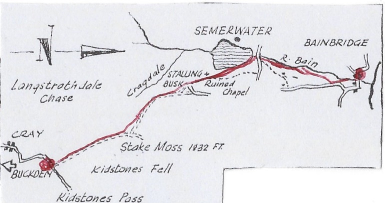
- SD 940 804 The walk starts of the summit of Kidston Pass where on clear signal to the driver DalesBus 875 bus will stop. Head through the gate along the stony track due north – this follows the old Roman Road known as the Stake Pass. This was originally built by the Roman General and brilliant engineer Julius Agricola, sometime in the late first century as a military campaigning road to connect his strategic forts in Wharfedale at Olicana (modern Ilkley) or Virosidvm (Bainbridge) .These garrisons were linked by the strategic road network to rapidly enable the bringing of reinforcements. They were designed to subdue the warlike Celtic tribes known as the Brigantes. You are literally treading in the footsteps of Roman soldiers. However this ancient road linking Upper Wharfedale and Upper Wensleydale is now also a Public Byway, with full vehicular rights which means on summer Sundays it often has to be shared with noisy motorcyclists and 4×4 vehicles. Continue with ever finer views as you ascend Stake Pass, climbing for around 2 kilometres– 1¼ miles .
- SD 934 828 The views on a clear day the summit of the Pass, the huge area of peatland known as Stake Moss, along the watersheds and down into Raydale, are truly memorable. Keep ahead through the gate where you will find a stile on the left which leads to a footpath which takes a shorter route across rough pasture, (also avoiding 4x4s) marked by a series of stiles in the walls, to rejoin the Stake Pass track, after descending Silky Gill and Shaw Gate. Another option is simply to remain on the Stake Pass track.
- SD 917 854 Where a narrow enclosed way. Bob Lane, leaves Stake Pass (here know as High Lane) take the enclose track left which leads down into Raydale. Turn left at the tarmac lane into the little hamlet of Stalling Busk.
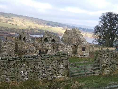
- SD 915 859 Look for a blue plaque on a cottage wall in Stalling Busk which commemorates where a meeting of Ramblers and politicians took place to finalise what was to become the iconic Countryside and Rights of Way Act 2000. Continue straight ahead, but soon take the gated and narrow path past the hamlet’s picturesque and much photographed ruined church (which was simply abandoned when a newer one replaced it a century or so ago), the path now descending towards Semerwater.
- SD 920 868 Follow the path which continues northwards close to the edge of Semerwater. This ancient glacial lake is one of the few natural lakes in the Yorkshire Dales. It is now an important nature reserve and wildlife sanctuary, one of the last strongholds of our native white clawed crayfish. The lake is the setting of a famous Yorkshire legend, one which strongly appealed to Muppett. It tells how the lake was created by a mighty earthquake, and the village with its heartless inhabitants were flooded under the lake forever, by an avenging angel. Everyone perished except for an impoverished farmer and his wife who gave the avenging angel, disguised as a beggar, food and shelter – a grim tale, albeit with a powerful moral statement:
Semerwater Rise, Semerwater sink,
swallow all the town, save this little house
where they gave me food and drink
Follow the path through stiles as it eventually veers right to join the lane at Blean Farm. Turn left to the edge of the lake and the great Carlow Stone boulder, immortalised by a watercolour by one of England’s greatest Painters J.M.W. Turner.
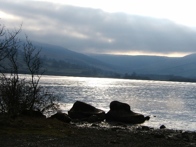
- SD 923875 Another legend suggests that the Carlow Stone and other huge stones came from the top of nearby Addlebrough after a fierce battle between devil and a giant. More prosaically they were almost certainly carried here by one of the many great retreating glaciers that also left the lake. Semerwater was also the home of late Stone Age fisher-huntsmen who maybe built Crannog-style huts on stilts over the edge of the lake. These people might have been the origin of the Semerwater legend in somehow recaptured in folk memory.
Continue along the lane but take the stile to the right before the bridge over the River Bain which leads to an attractive riverside path over stiles.
- SD 927 884 The River Bain has the distinction of being perhaps England’s shortest river, being barely two miles long. Follow the path as it leaves the river, curving right then crossing left over stiles and ascending the low hill directly ahead, known as Bracken Hill. The path now goes close to the lane from Semerwater on the right, but a more direct parallel route avoiding the tarmac bears off left, downhill heading for the main A64 just above the actual Bridge that gives Bainbridge its name. Note the small hydro-electric station above the bridge whose twin Archimedes screws provide valuable green energy for the people of the village.
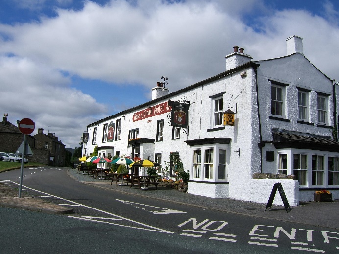
- SD 935 901 Turn left, taking care with the traffic along the main road, into the little village of Bainbridge, noted for its beautiful village greens, its old water mill (now a guest house) and ancient Rose and Crown Inn which goes back to Plantagenet times. The inn still has the hunting horn displayed which was blown on winter evenings to guide benighted travellers to safety through what was the ancient Hunting Forest of Wensleydale. Equally fascinating, the low, grassy, flat-topped hill just to the immediate east of the village centre known as Brough Hill, is the site of the Roman Fort of Virosidvm, served by the two-thousand-year-old road from Olicana, part of which you have walked today.
Bainbridge is appropriately enough now the headquarters of the Yorkshire Dales National Park Authority – the present guardians of this amazing historic and landscape.
Your DalesBus bus stop back to Wharfedale and Leeds is on the edge of the village green on the opposite site of the road to the little bus shelter, just below the inn.
If you would like to find out about another one of Muppet’s favourite walks you can purchase our booklet here:
More information about it can be found: here
